Tech Files
Hydrographic Notes
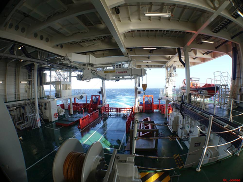
MacGregor: Specialist solutions for research vessels
MacGregor is outfitted to rise to the challenges posed by evolving requirements for research vessels to undertake increasingly complex tasks within the confines of severely limited space on board. With research vessels often pre-booked for up to three years, it is essential that mission-critical systems operate reliably with maximum availability.
MacGregor has supplied deck machinery to thousands of vessels globally, and its solutions cover deck machinery and deck handling equipment for the full range of oceanographic, polar and fishery research vessels. Systems include self-contained CTD winches as well as solutions for ROV deployment, coring and deep-sea towing.
Notable recent examples of innovation and collaborative development include the RSV Nuyina, an icebreaking research survey vessel designed and built to support and supply Australian bases in Antarctica. Nuyina was built by Damen Shipyards in Galati, Romania for the Australian Antarctic Division of the Australian Government and trialled at Damen Schelde Naval Shipbuilding in Vlissingen, the Netherlands. The vessel was designed by Danish ship designer KNUD E. HANSEN and classified by Lloyd's Register.
Delivered in 2021, Nuyina can deploy a wide range of vehicles, including helicopters, landing barges and amphibious trucks, to support supply operations. Pivotal in sustaining operations is a comprehensive range of solutions from MacGregor for the handling of scientific equipment including a winch package, cranes and deck handling machinery, hatch covers, hydraulic power units, davits and steering gear.
The Rotterdam Reef
In collaboration with the Municipality of Rotterdam, Rijkswaterstaat and Boskalis, the start-up Reefy from Delft will test a modular artificial reef system that protects the riverbank against large ship waves and stimulates the development of nature. Reefy combines biology and hydraulic engineering to develop nature-inclusive solutions for water safety.
Reefy's innovation consists of massive “Lego-like” blocks, which have been hydrodynamically designed and tested in the Deltares wave flume. By assembling these blocks underwater, a stable structure is formed that breaks waves but also creates an underwater labyrinth where fish and other species can shelter and breed. The blocks are made of sustainable concrete with a special texture on the surface. With this, the start-up aims to stimulate all kinds of biological growth such as oysters and mussels to create a living layer that promotes biodiversity and can grow with sea level rise, requiring less maintenance. Innovative materials to stimulate this are now being further tested behind the scenes in collaboration with Diergaarde Blijdorp.
Reefy was founded by Jaime Ascencio and Leon Haines. Ascencio worked as an engineer in Mexico and the Caribbean Sea, where he sought sustainable solutions for resorts against coastal erosion. The current artificial reefs on the market turned out to be unstable and cannot be used as breakwaters. To find a solution, he left for TU Delft to follow the Master's in Coastal Engineering. Haines is a marine biologist who, after studying Integrated Coastal Management / Marine Biology, spent five years working on coral reef restoration projects on islands in Thailand, the Maldives and Indonesia.
Since the end of 2013, the Municipality of Rotterdam, Rijkswaterstaat, the Port of Rotterdam and the World Wildlife Fund have been working together on sustainable, nature friendly riverbanks in the Nieuwe Waterweg and the Scheur. They do this, among other things, with clean residual material from construction. The project is called ‘De Groene Poort’ or 'Green Gate'. To keep these natural banks in place and to protect them against the waves of ships and current, breakwaters are needed to create a foreshore. Rijkswaterstaat and the Municipality of Rotterdam are looking for more sustainable solutions for this than the usual rock or stone dams. By testing these reef innovations in collaboration with Reefy, the Municipality of Rotterdam and Rijkswaterstaat hope to find a resilient and sustainable solution to restore the natural values in the tidal area of the Maas river.
eTrac Earns $13M Hydrographic Survey Contract
The U.S. Army Corps of Engineers Galveston District awarded eTrac, a Woolpert Company, with an architect-engineer contract to provide hydrographic surveying and mapping services within the Galveston District and potentially the USACE Southwest Division. The five-year, Multiple Award Task Order Contract has a total shared capacity of $13 million. It will support planning, design, construction and maintenance projects to help advance navigation safety, dredging, flood control, beach nourishment, hurricane response and similar USACE Civil Works projects.
Under this contract, eTrac will conduct hydrographic and bathymetric surveys of offshore waters, shallow and deep draft inland waterways and channels, coastal areas, inland lakes, rivers and other bodies of water. eTrac will collect and process shallow water, multibeam sounding data, side-scan sonar data and vertical-beam echosounder data to support a wide range of services, which could include planimetric, boundary and utility surveying. In addition, eTrac and Woolpert will support this contract with photogrammetric mapping, engineering and design; geodetic control surveys; and the collection, processing and management of high-accuracy GIS data.
A bathymetric chart of Grand Cayman.
Image courtesy UKHOUKHO Data Helps to Drive Growth on Cayman Islands
The UK Hydrographic Office (UKHO) has completed a seabed mapping survey for the Cayman Islands, uncovering information about the depth and nature of the seabed and its ecosystems.
Geospatial data from the six-month study, launched in November 2021, was undertaken through the UK Government’s Conflict, Security and Stability Fund (CSSF), under the Overseas Territories Seabed Mapping Program. Data was gathered over the land and in the sea around the islands to depths of around 40 meters.
The data will support the islands’ maritime trade and economic growth by shedding light on the seabed in the surrounding waters, enabling safe navigation and helping to drive the territory’s sustainable blue economy.
A small aircraft that used lidar data-gathering techniques was deployed twice daily for up to four hours to collect the data. The aircraft’s onboard survey equipment gathered information on water depth and land heights, while also capturing high-resolution images of the entirety of the three islands.
Meanwhile, the UKHO installed four tide gauges in the waters surrounding the islands. These gauges will collect tidal data that can be used by scientists to understand the impact of climate change on sea levels and to assist in marine conservation efforts.
Image shows 10m SDB and bathymetric contour lines produced from numerous Sentinel 2 images in the Fox Basin, Arctic Canada.
Image courtesy TCartaTCarta Opens Canadian Affiliate Office
TCarta Marine have formed TCarta Canada based in Ottawa, Ontario. Offering the complete line of TCarta satellite-derived bathymetry (SDB) services and Trident SDB Toolbox software, the affiliate office is a partnership between TCarta Marine and Prof. Anders Knudby, a well-known marine geospatial researcher and consultant in Canada. TCarta Canada announced its first contract – a pilot project to update bathymetric navigation charts for Baffin Island’s Cape Hooper and Kangok Fjord with SDB technology. The contract is administered by the Canadian Hydrographic Services, which has previously purchased SDB maps from TCarta.
At the heart of TCarta Canada’s offerings will be the new Trident (SDB) Toolbox, now available as a software-as-a-service product. The Toolbox is a series of software applications that operate within Esri ArcGIS Pro and allow organizations to perform their own extraction of bathymetric measurements from satellite, aerial, and UAV imagery.
Figure 1. Summary of the method from collecting data on the PML Explorer to model training and plastic detection using the AI algorithm.
Image courtesy PMLFloating Plastic Litter Detected, Categorized via AI
A team of scientists from Plymouth Marine Laboratory have ‘trained’ an Artificial Intelligence (AI) model to recognize and classify the different types of marine plastic captured in images shot by a video camera mounted on the side of a boat.
Funded by the PML internal research program and the European Space Agency (ESA), the study - titled “Detection and Classification of Floating Plastic Litter Using a Vessel-Mounted Video Camera and Deep Learning” - was carried out as part of an undergraduate placement project, with the results now published in the journal Remote Sensing.
The AI model itself was trained using the MAGEO supercomputer (Massive GPU Cluster for Earth Observation) which is based at PML and operated by the Natural Environment Research Council Earth Observation Data Acquisition and Analysis Service (NEODAAS).
The model was able to classify the presence or absence of plastic in an image with an accuracy of 95% and capable of differentiating different types of plastic - for example a plastic bag or bottle - with an accuracy of 68%.
It is now envisaged that the technique could be more widely applied using crewed or autonomous vessels, such as PML’s proposed long-range autonomous research vessel, the Oceanus, thereby revolutionizing existing capabilities to monitor floating plastic litter.