Academia
Understanding Deep Currents
Understanding the Deep Currents of the Gulf of America
Since 2018, the National Academies of Sciences, Engineering, and Medicine has been conducting the Understanding Gulf Ocean Systems (UGOS) initiative, a long-term research campaign to improve understanding and prediction of the Gulf of America Loop Current System. The overarching goal of UGOS is to improve forecasting of the Gulf’s oceanographic conditions at spatial and temporal scales relevant to key stakeholders, particularly in reducing risks for offshore energy exploration and production. This is achieved through cost-effective ocean observations, advanced data assimilation techniques, and improvements to forecast models. More than 100 researchers from 30 organizations (including US and Mexican academic institutions, federal agencies, and private industry) are contributing to this critical effort.
By Jan van Smirren, Technical Coordinator of National Academies of Sciences, Engineering, and Medicine’s Understanding Gulf Ocean Systems initiative
Sonardyne Origin 65 prior to deployment
©University of Rhode IslandPreviously, strong currents in the deepwater Outer Continental Shelf (OCS) have been identified, extending from 1000m (3000ft) below the water surface down to the sea floor with consistent speed and direction, that intensify as they get close to the seabed. These pulses of strong currents propagate along the Sigsbee Escarpment from East to West. During these events, the deep currents can exceed one knot making them a critical factor for offshore energy operations.
The events have been the subject of a Safety Alert from the US Department of the Interior's Bureau of Safety and Environmental Enforcement (Safety Alert Number 180). Analyses of observational datasets have shown that the events have characteristics similar to Topographic Rossby Waves (TRW), which have been identified in other ocean basins. These are large-scale features that are characterized by little change in speed and direction with elevation above the seabed. They intensify as the seabed is approached until the effect of friction at the seabed reduces their speed.
Studies of TRWs have been undertaken by Fugro, BOEM, and the Deepstar Consortium. Several hydrodynamic numerical models are run routinely in a forecast mode that provide output in the Gulf, such as the NOAA Global Real-Time Ocean Forecast System (RTOFS) that is based on the 1/12° HYbrid Coordinates Ocean Model (HYCOM). Unfortunately, due to the horizontal and vertical grid size, these models are too coarse to properly represent TRW-like motions along the steep and narrow Sigsbee Escarpment.
Beginning in 2008, the Deepstar Consortium commissioned Florida State University (FSU) to undertake a number of modelling studies, and the model was then used to hindcast the BOEM and DeepStar measurements, culminating in a well-validated model. In the process, FSU indicated that the TRWs were being generated by the interaction of the Loop Current (or a recently detached eddy) and its associated meanders on the outer slope of the Mississippi Fan, just south of the delta. The model was subsequently run in a 50-year hindcast mode to produce a set of outputs that were sufficient to allow the development of operational and design criteria.
Understanding Causes of Deepwater Currents
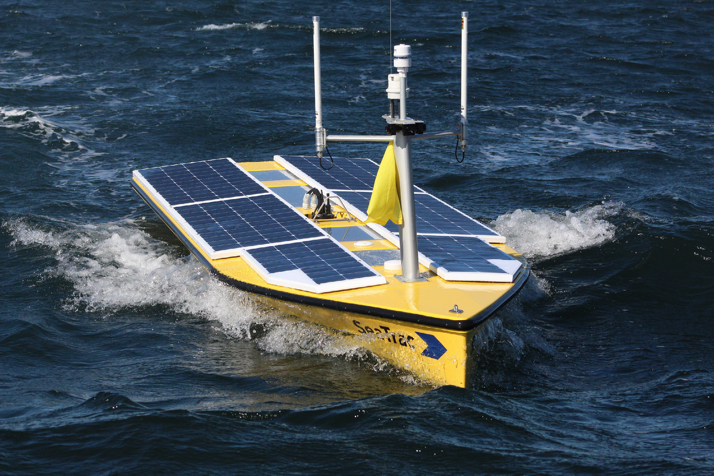
SeaTrac ASV
©SeaTracOne key component of the UGOS campaign undertaken by the University of Rhode Island (URI) and FSU has been to improve the understanding and prediction of the TRWs that cause these strong deepwater currents. The team uses state-of-the-art monitoring systems and models building on the previous studies, particularly the work previously funded by the Deepstar Consortium.
A TRW Antenna of seabed instrumentation was deployed by URI in 2024, including seven Pressure Inverted Echo Sounders (PIESs) and four Sonardyne Origin 65 Acoustic Doppler Current Profilers (ADCPs), which integrate PIES and acoustic modem technology with a 65 kHz ADCP. The array was deployed east of the Sigsbee Escarpment to allow the TRWs to be monitored as they propagated through the mooring locations toward the escarpment where they intensify.
The PIES is an ocean bottom-moored instrument that measures vertical acoustic travel time (VATT) round trip from the seafloor to the sea surface. The instrument is also fitted with a pressure sensor. The VATT varies principally due to changes in the temperature profile of the water column. Applications in several large-scale ocean currents and frontal zones have demonstrated that VATT can be re-interpreted as geopotential height (dynamic height), which varies due to the Loop Current meandering and Loop Current Eddies passing over the instrument. In the Gulf of America, the vertical profiles of geopotential height, which vary with time, may be determined from VATT measurements, and data from laterally separated PIESs can be used to estimate horizontal gradients in dynamic height, from which geostrophic ocean current profiles may be calculated.
The ADCP sends out an acoustic ping along 4 beams in the Janus configuration. By monitoring the doppler shift backscattered sound in each beam, the water velocity can be determined in the axis of each beam, which can subsequently be resolved into speed and direction. Additionally, the backscattered sound is time gated which slices the water column up into discrete layers for which individual velocity readings are obtained. In the case of the Origin 65, profiles of the currents are obtained for the bottom 550m of the water column.
Historically, the only methods of recovering data from these instruments involved mobilizing a research vessel and recovering the instruments or downloading data from the instruments in-situ using a survey vessel, both of which come with a considerable cost. As part of this program working with the instrument manufacturers, Sonardyne and SeaTrac, a system was developed to allow data from the TRW Antenna to be harvested autonomously using a solar and battery powered SeaTrac Uncrewed Surface Vehicle (USV).
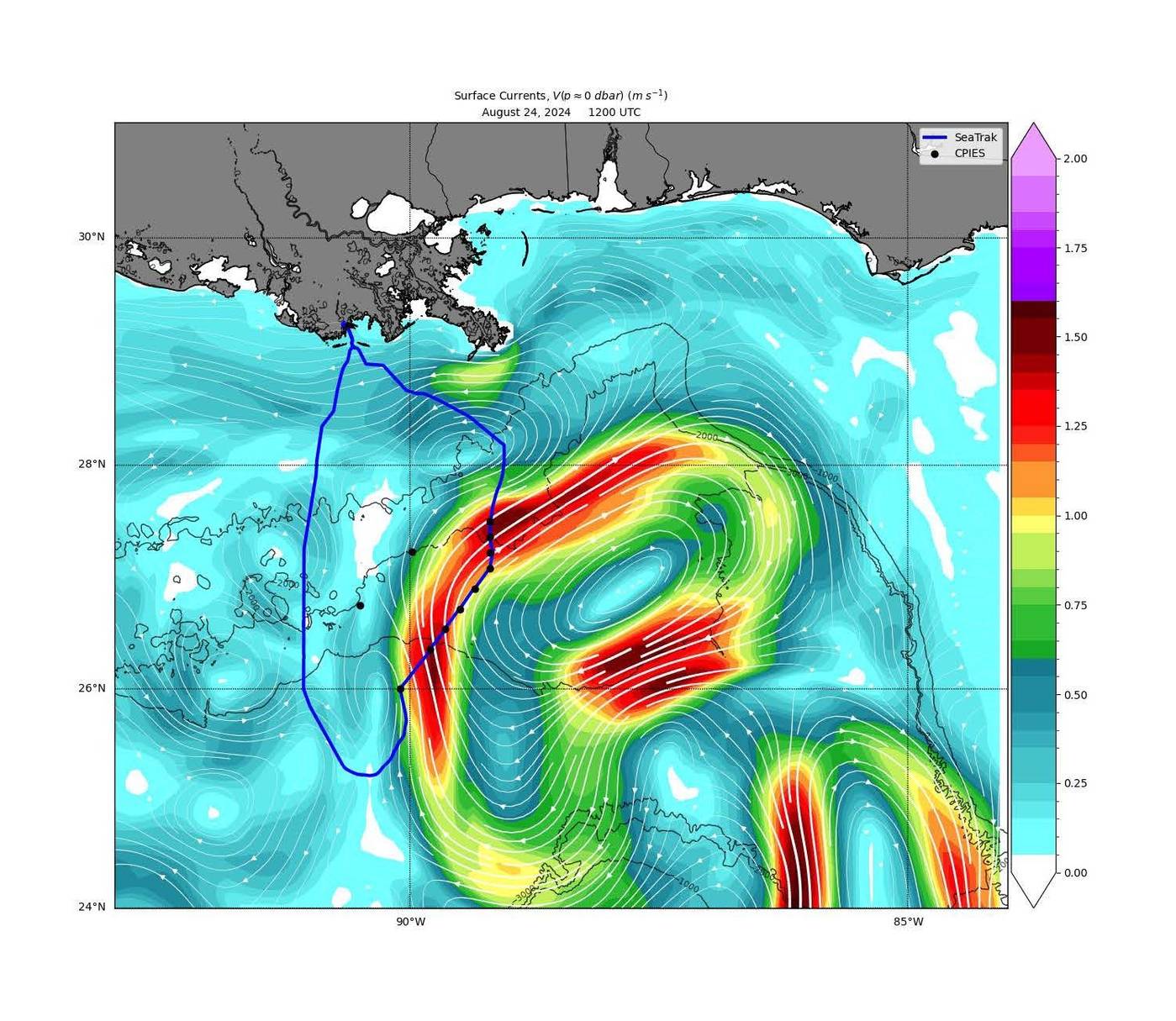
The track of the ASV (blue) superimposed on a color contoured surface velocity field (in m/s) of the Loop Current
©University of Rhode IslandDuring August 2024, the first mission was undertaken. The figure shows the track of the SeaTrac USV, over the TRW Antenna (black dots). Despite the presence of the Loop Current with surface currents exceeding 1.5m/s (~ 3 Knots) over the array, the USV was able to successfully navigate to the instrument sites and download the data from the CPIES and Origin 65s using the Sonardyne acoustic modem telemetry system.
Examples of the current speed data derived from the TRW Antenna are presented below. The data show a strong correlation between the locations of the monitoring systems, illustrate that the area of generation of the TRWs varies, and that the frequency of the waves is higher when their point of origin is more Northerly. The maximum speeds observed were close to 1 knot 50m above the seabed.
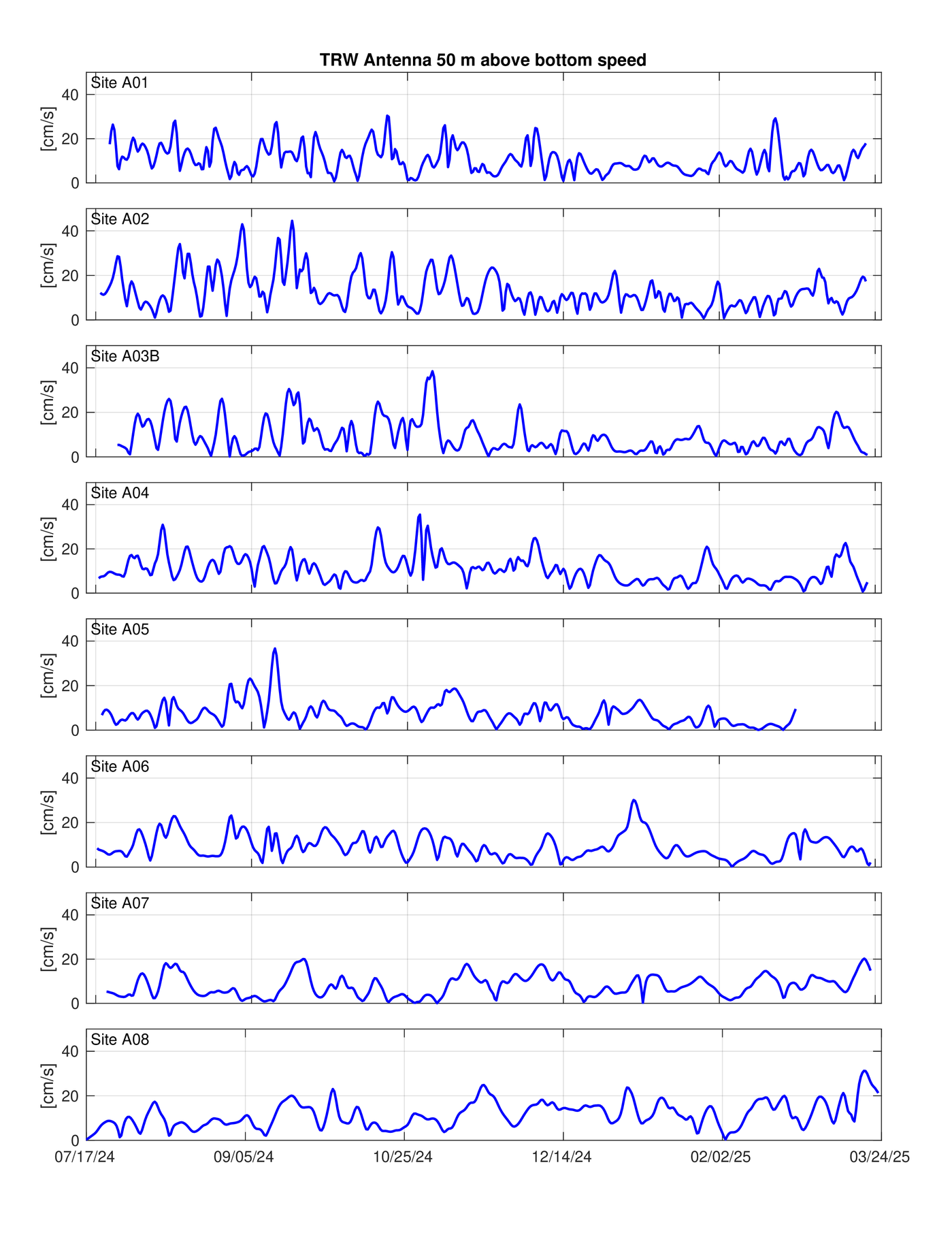
Time series of velocity data for seven locations exhibiting TRWs
©University of Rhode IslandNew Approaches for Improved Forecasting
To go beyond observations, UGOS researchers at FSU and Florida A&M University, building on the prior research funded by the Deepstar Consortium, are using a high-resolution model to simulate and predict TRW behavior. The model, developed from the Navy Coastal Ocean Model with high vertical and lateral resolution, now replicates observed deep-sea currents far more accurately than previous models.
Another breakthrough is the use of Self-Organizing Maps (SOMs), a machine learning approach, to improve TRW forecasting from readily obtainable data. By analyzing satellite-derived or model analyses of sea surface height (SSH) patterns, researchers can now estimate when and where deep currents will intensify.
Throughout the research there has been routine engagement with experts from oil and gas companies to ensure the research addresses these key stakeholders’ needs and provides an opportunity for the techniques developed to be transitioned to an operational system, reducing risks for offshore energy exploration and production.
About the Author
Jan van Smirren
Jan van Smirren is the Technical Coordinator of the National Academies of Sciences, Engineering, and Medicine’s Understanding Gulf Ocean Systems initiative. With over 40 years of experience in oceanography, van Smirren is currently an oceanographer with Ocean Sierra and DHI Water and Environment. Prior to this he was Partnership Managing Director for the Energy Sector at BMT, and previously occupied global and regional senior management positions in the UK, Singapore and USA with Fugro.
