Feature
Science & Technology
From Sea to Shining Sea: Addressing Offshore Wind Challenges with Buoy-based Technology
Facilitating meteorological and oceanographic data collection using validated methods to support the U.S. offshore wind industry
By Alicia M. Mahon, Lindsay M. Sheridan, and Mark Severy − Pacific Northwest National Laboratory
Buoys off Martha’s Vineyard, Massachusetts undergoing validation in January 2020.
Image courtesy of Ocean Tech Services, LLC and Pacific Northwest National LaboratoryOffshore wind development planning and deployment are accelerating in the United States in pursuit of national and regional decarbonization goals. However, development is currently challenged by a lack of long-term observations of meteorology, particularly above the immediate ocean surface and including the rotor heights of offshore wind turbines. Such observations are needed not just by the wind industry to support specific developments but also by the research community to fill knowledge gaps regarding physical processes that affect the accuracy of computer models. Researchers need observations over annual cycles or longer to validate models under the full range of meteorological and oceanographic (metocean) conditions that wind turbines will experience. Additionally, information on the potential environmental effects of offshore wind energy development is needed to enhance our understanding of potential wind-wildlife interactions to support siting and permitting.
Measurement of metocean conditions in remote, complex offshore environments is challenging enough, and the offshore wind community endures the additional complexity of needing information at turbine hub heights hundreds of feet above the surface of the water. To address this challenge, researchers at the Pacific Northwest National Laboratory (PNNL) manage two buoys for the U.S. Department of Energy that are equipped with instruments, including Doppler lidars, to measure and make publicly available site conditions for the offshore wind community. Available on the U.S. Department of Energy’s Data Archive and Portal (https://a2e.energy.gov/data), which is also managed by PNNL, buoy metocean data are freely accessed and used by offshore wind developers, consultants, regulators, and researchers to validate wind models, improve the understanding of air-sea interactions, reduce uncertainty and risk in characterizing wind resources, and support offshore wind siting and design.
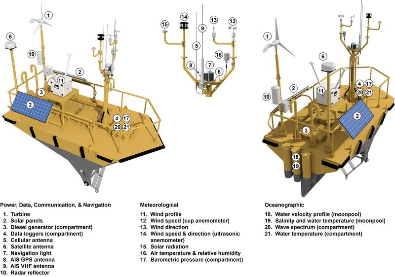
Schematic of lidar buoy instrumentation
Buoy-based Metocean Data Collection and Analysis
The lidar buoys collect a comprehensive set of metocean measurements needed for offshore wind resource characterization. The centerpiece of the instrumentation suite for each buoy is a motion-corrected lidar system that provides profiles of the wind speed and direction up to 250 meters above the sea surface. In addition to a lidar, each buoy collects complementary oceanographic and near-surface meteorological data, such as ocean current profiles and air and sea temperature.
The buoys provide a cost-effective, innovative, and mobile solution for gathering the long-term observations needed to comprehensively characterize the wind resource at diverse locations of offshore wind development interest.
After procurement in 2014, the buoys underwent testing at PNNL’s Marine and Coastal Research Laboratory in Sequim, Washington. The goal was to assess the performance of all sensors, power systems, and communications links with the buoys deployed in a location representative of a real operational environment.
East Coast Deployments
In December 2014, one buoy was deployed 42 km off the coast of Virginia, and in November 2015, the second buoy was deployed 5 km off the coast of New Jersey. Each buoy collected over a year’s worth of continuous metocean data, providing the first open-ocean observations of hub height wind speed and direction over a full annual cycle in the United States. The buoys diligently collected data during conditions that are experienced by East Coast offshore wind farms, ranging from gentle winds and seas to hurricanes and nor’easters.
Observations from the East Coast buoy deployments propelled offshore wind energy research in a variety of impactful directions. First, researchers thoroughly characterized and examined the wind resource at the two locations of offshore wind energy development according to seasonal and diurnal trends, origin of the wind resource, and an assortment of metocean conditions such as atmospheric stability and wave age.
Once researchers established the behavior of the wind resource off Virginia and New Jersey, they employed the buoy observations to validate theoretical wind speed profile assumptions, such as the logarithmic wind profile from Monin-Obukhov Similarity Theory, and reanalysis models that incorporate them. Reanalysis models are commonly engaged in setting wind energy project performance expectations, and the East Coast buoy observations revealed a slow wind speed bias in these models, which translated to simulated gross capacity factors up to nine percentage points lower than the capacity factors suggested by the observations. These findings inspired further research into potential improvements in wind resource simulations through high-resolution models with coupled atmospheric and oceanic feedback.
Performance testing of lidar buoys at Pacific Northwest National Laboratory’s Marine and Coastal Research Laboratory in October 2014
Buoy Upgrades and Lidar Validation
Following their East Coast mission, the buoys were outfitted with upgraded lidar systems that better capture wind data at extended heights above the sea surface, allowing for improved understanding of wind behavior at increasing hub heights and across the large rotor-swept area of offshore wind turbines. The buoys returned to Atlantic Ocean waters in 2019, this time off the coast of Martha’s Vineyard, Massachusetts to validate the new lidar systems using the observational technology available at Woods Hole Oceanographic Institute.
Validating the readings from the lidar buoys through an offshore measurement campaign helps evaluate the accuracy and uncertainty of the subsequent wind resource measurements. The validation process involves deploying each lidar buoy near a trusted reference source for comparison. The lidar must collect measurements across a range of wind conditions, including low- and high-wind speeds, that can be evaluated against the reference source. A typical validation process can take between four and eight weeks to capture enough measurements across the required wind speed range. Guidelines for validating the performance of floating lidar systems have been published by the Carbon Trust, including their Roadmap for Commercial Acceptance of Floating Lidar Technology and a set of Recommended Practices for Floating Lidar Systems, which was later published by the International Energy Agency Wind Technology Collaboration Program.
West Coast Deployments
After a successful validation campaign, the buoys were deployed in September and October 2020 off the northern and central California coasts to support gathering metocean measurements that will inform decisions on potential leasing of wind energy sites in the Pacific Ocean. In addition to gathering valuable metocean data to better understand wind energy potential off the West Coast, a PNNL-developed stereo-vision wildlife tracking technology, called ThermalTracker-3D, was installed on one of the buoys to validate the system for tracking bird and bat behavior around remote wind turbines. Using a pair of thermal video cameras, the technology remotely senses movement of animals and objects, day and night, near critical assets such as offshore wind turbines. ThermalTracker-3D is designed to provide data to help inform siting and permitting decisions for wind turbines, and it allows monitoring of bird and bat behavior following offshore wind farm construction to help fill gaps in the understanding of avian-wind technology interactions.
Investigation is underway using the West Coast data to establish wind project performance potential and to understand the impacts of Pacific metocean conditions on the available wind resource and the theories and models that simulate it. In addition, the current buoy deployment allows researchers to perform an East Coast versus West Coast comparison of model hub height wind speed accuracy. Model errors are being classified according to conditions observed in both diverse environments of offshore wind development interest, such as stable boundary layers, and according to conditions unique to each coast, for example the coastally trapped wind reversals that occur on the West Coast. The results of the analyses will set expectations of uncertainty for model users along with identifying areas for improvement for future model development.
Buoy stationed off Morro Bay, California for deployment in September 2020
R&D to Support Wind Resource and Site Characterization Research
The current and foreseeable expansion of offshore wind energy deployments in the United States necessitates the development of new, innovative instruments for resource characterization and environmental monitoring. Building on the success of the East and West Coast buoy deployments, PNNL is developing an instrumentation test buoy that will serve as an offshore platform to evaluate the performance of new instrumentation under development for offshore metocean and/or wildlife monitoring. Possible test sensors for the platform include radar wind profilers, temperature profilers, surface atmospheric turbulence measurements, weather and precipitation measurement, and wildlife tracking and monitoring instrumentation. The test buoy is being designed to accommodate a range of future sensors both above and below water and to have additional capacity for weight, electric power, mounting locations, and data storage and transmission. The buoy will have the ability to adapt to the needs of new instrumentation and expand systems to meet power and data requirements for test instrumentation.
One such piece of new instrumentation that will be tested on the test buoy is an eddy covariance flux system under development by the University at Albany’s Atmospheric Sciences Research Center. The eddy covariance flux system is being designed to integrate with a lidar buoy to measure turbulence momentum and buoyancy fluxes near the sea surface. Deploying the eddy covariance flux system alongside a Doppler lidar will allow the continuous in situ characterization of the atmospheric surface fluxes, turbulence, and wind profiles that influence wind power generation potential and fluctuation of turbine loads. Researchers can use these measurements to evaluate and refine wind resource assessment and short-term to medium-range forecast models.
The Future: Helping the Nation Deploy 30 GW of Offshore Wind by 2030
The U.S. offshore wind development and operational pipeline stands at a potential generating capacity of 35.3 GW, according to the 2021 Edition of the U.S. Department of Energy Offshore Wind Market Report, a capacity that is poised to support the 30 GW by 2030 national offshore wind energy goal announced by the Biden Administration. With strong winds prevalent over our country’s largest bodies of waters, the U.S. wind energy industry is pursuing energy development in the Atlantic and Pacific Oceans and the Great Lakes. To design wind farms and select the most appropriate locations, engineers and decision makers need to understand the offshore wind and ocean conditions that impact energy production expectations, equipment reliability, safety, and project costs.
With support from the U.S. Department of Energy, PNNL manages the deployment of lidar buoys to facilitate offshore measurement campaigns that advance our understanding of the offshore environment and provide the observational data needed for model validation, particularly at hub height where offshore observations are particularly lacking and difficult to obtain. The metocean data collected by the buoys support the estimation of annual energy production, economical and reliable integration of wind energy, and characterization of turbulence for developing and applying design load criteria. The data also provide a better understanding of the offshore development environment that can improve siting, optimize designs, improve reliability and performance, increase safety, and reduce capital and operating costs.
Providing offshore wind stakeholders with open access to the buoy data facilitates the informed decision-making needed to catalyze development in support of sustainable, equitable offshore wind energy.
About Pacific Northwest National Laboratory
Pacific Northwest National Laboratory (PNNL) draws on its distinguishing strengths in chemistry, Earth sciences, biology, and data science to advance scientific knowledge and address challenges in sustainable energy and national security. Founded in 1965, PNNL is operated by Battelle for the U.S. Department of Energy’s Office of Science, which is the single largest supporter of basic research in the physical sciences in the United States. The U.S. Department of Energy’s Office of Science is working to address some of the most pressing challenges of our time.
Alicia M. Mahon, Ph.D., PMP
Alicia Mahon is the Offshore Wind and Dynamics Team Lead at PNNL focusing on developing marine technology solutions to support offshore wind development.
Lindsay Sheridan, MS
Lindsay Sheridan is an atmospheric scientist at PNNL with a focus on data analysis, model validation, and performance evaluation for onshore, offshore, and distributed wind.
Mark Severy, P.E.
Mark Severy is a mechanical engineer at PNNL who conducts research to facilitate the deployment of renewable energy resources including offshore wind.