Navigation Transformation
The development of the new hydrographic framework S-100 has been underway for two decades, but now a date has been set for its implementation: January 1, 2026.
By Wendy Laursen
S-100 sea trials test area in the St. Lawrence River
Source: Fisheries and Oceans CanadaThe Canadian Hydrographic Service (CHS) is taking a leading role in validating the new S-100 hydrographic framework with the June 2025 launch of sea trials on the St. Lawrence River. The primary objective of the six-month trial is to enable software developers and end users to start working with real data before the framework’s planned global implementation on January 1 next year.
The S-100 framework is a new global standard created by the International Hydrographic Organization (IHO), in collaboration with other hydrographic offices around the world, that enables the integration of diverse datasets within a single Electronic Chart Display and Information System (ECDIS) or other hydrographic application platforms. Users will be able to combine various data layers with electronic navigational charts (ENCs) including detailed depth information and dynamic information on tides and currents.

S-100 builds on the digital foundation of S-57, the standard for ENCs since 1992, and the goal is to enhance situational awareness and decision-making, particularly in coastal waters and ports.
Following the adoption of Edition 5.2.0 of S-100 in June 2024, operational editions of key S-100-based product specifications were approved in December 2024. These include:
-
S-101: Electronic Navigational Charts
-
S-102: Bathymetric Surface
-
S-104: Water Level Information
-
S-111: Surface Currents
-
S-124: Navigational Warnings
-
S-129: Under Keel Clearance Management.
The St. Lawrence River trials are a collaborative effort involving CHS, the Canadian Coast Guard, Teledyne Geospatial, Electronic Chart Centre and PRIMAR. The CHS is offering S-100 digital navigation products and services free of charge to interested parties so they can test their performance in real-life scenarios and simulated environments. The complex conditions of the St. Lawrence River, such as varying water depths, changing currents and navigational aids, make it an ideal testing ground.

The trial is underway thanks to the leadership of Louis Maltais, Director, Navigation Geospatial Services and Support at CHS, and the dedicated efforts of the hydrographers and CHS staff who support the sea trial project behind the scenes. It’s been a chicken and egg situation, says Maltais. The data hasn’t been available, so the end-user software hasn’t been finalized for real-life testing. “Navigation is a team sport – from the producers of the data to the distribution chains, the software developers, all the way to the user. Everyone is impacted when we make changes.”
Maltais is working to ensure that the ownership and integrity of the various data layers is clear. CHS is using peer-reviewed surface current models, for example, so that navigators and emergency responders can be confident in the quality of the data.
Several Canadian shipping and software companies are already involved in the St. Lawrence River trial, along with the Canadian Navy, but far from being a Canada-centric trial, Maltais hopes that stakeholders from around the world will get involved. These stakeholders could be ports, pilots, navigational product manufacturers and training facilities, and they can use the data to see how the new framework will enhance their own applications.
Maltais cites pilots as an example. “We are going to be able to speed up the training of pilots, because now they will have a complete dynamic picture of the waterway they are working in. The knowledge won’t be written in a small brown book and passed from generation to generation of pilot, because they will be able to see it.”
Some S-57 users have wondered why it has taken two decades to get to this point. “What people forget is that it's very easy to develop something for a specific port that the pilots can use, and of course it has benefit locally because all the stakeholders work together,” says Friedhelm Moggert-Kägeler, Senior Product Manager at Teledyne Geospatial. “What we're doing with S-100 is something different.
“What we want to achieve is that whoever builds an application does not have to talk with the organization that produces the data. And no matter where they go with the application, it should work on a global scale. All the stakeholders, the producers of the data, the manufacturers of the navigation systems and whoever is involved can develop their solutions against a reliable standard. It is very important to understand that we're not just talking about creating fancy displays or very reliable and accurate data. All the stakeholders can work with this data independently, and we want to minimize the room for different interpretations as much as possible.”
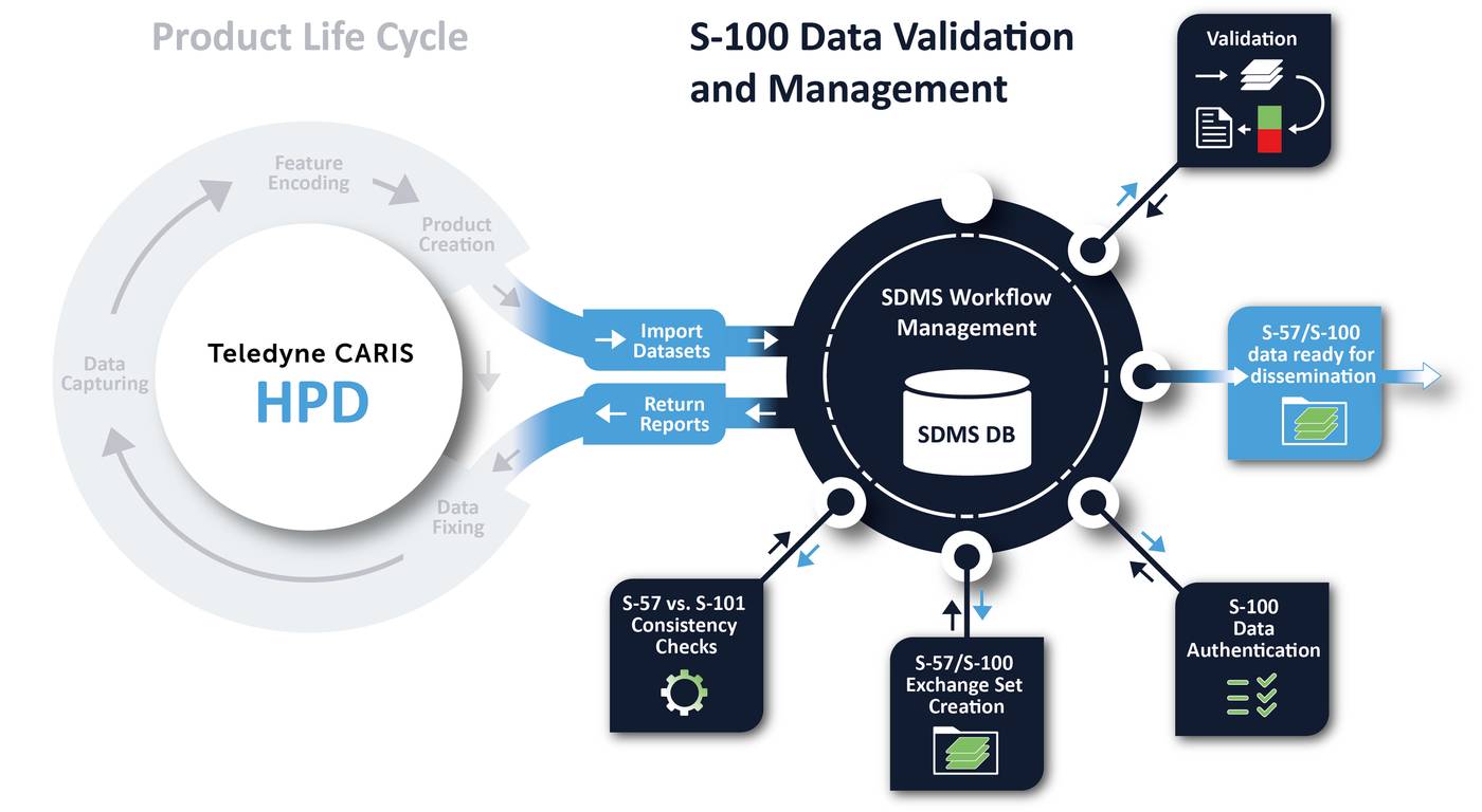
Teledyne subsidiaries Caris and SevenCs will be involved in the St. Lawrence River trial, and Moggert-Kägeler explains that Caris is focusing on software that organizations can use to produce the data. “This could be starting from source or updating existing data, merging data, so that all of these S-100 products, these layers, can be produced according to the IHO standards.”
SevenCs provides a comprehensive quality assurance process for the data to ensure readiness for dissemination before it goes to the chart distribution process.
ECDIS OEMs provide the hardware and software components onboard that makes use of the S-100 data. ECDIS functionality includes route planning and monitoring, real-time positioning, automatic chart updating, integration with other navigational sensors, display of official ENCs and support for navigational alerts and other safety features.
It’s possible to have data that has been successfully validated, but still, the quality is very poor, says Moggert-Kägeler. “This is what we're seeing today in S-57 data. It doesn't mean this will just change by switching to S-100. If you have poor data in S-57 and flip it to S-100, it's still poor data. This is very important. It is what people sometimes confuse. There are still areas where the source data is too old or old techniques were used and where budgetary constraints do not allow for a very expensive surveys using multi-beam or Lidar. Validation has no influence over the quality of the source data, but what we check is that the product that is being produced complies to the S-100 product specification.”
While the IHO has finalized all the phase 1 product specifications, there are still some under development such as the standards for the interoperability of all the layers and the test data sets that will be used for ECDIS type approval. So, the roll-out will be gradual. As of January 1, 2029, all newly built ships must be equipped with ECDIS systems that comply with the S-100 framework. Consequently, ECDIS type approvals will need to meet the updated performance standards that support the next generation of ENCs. These new systems must still be capable of displaying both S-57 and S-100 products.

