Subsea Mapping
Extended Continental Shelf
Drawing the Line: The Farthest, Deepest Limits
By Tom Ewing
An illustration from NOAA of how a ship collects multibeam data.
Image courtesy NOAAOn December 19, 2023, the US Department of State (DOS) announced a milestone accomplishment for an undersea mapping project that started in 2003: setting boundaries for the United States’ extended continental shelf (ECS), the final limits of a country’s land territory under the sea. For the US, that’s a vast expanse of territory in seven regions: the Arctic, Atlantic (east coast), Bering Sea, Pacific (west coast), Mariana Islands, and two areas in the Gulf of Mexico. DOS estimates the total ECS area is about 1 million square kilometers – about twice the size of California.
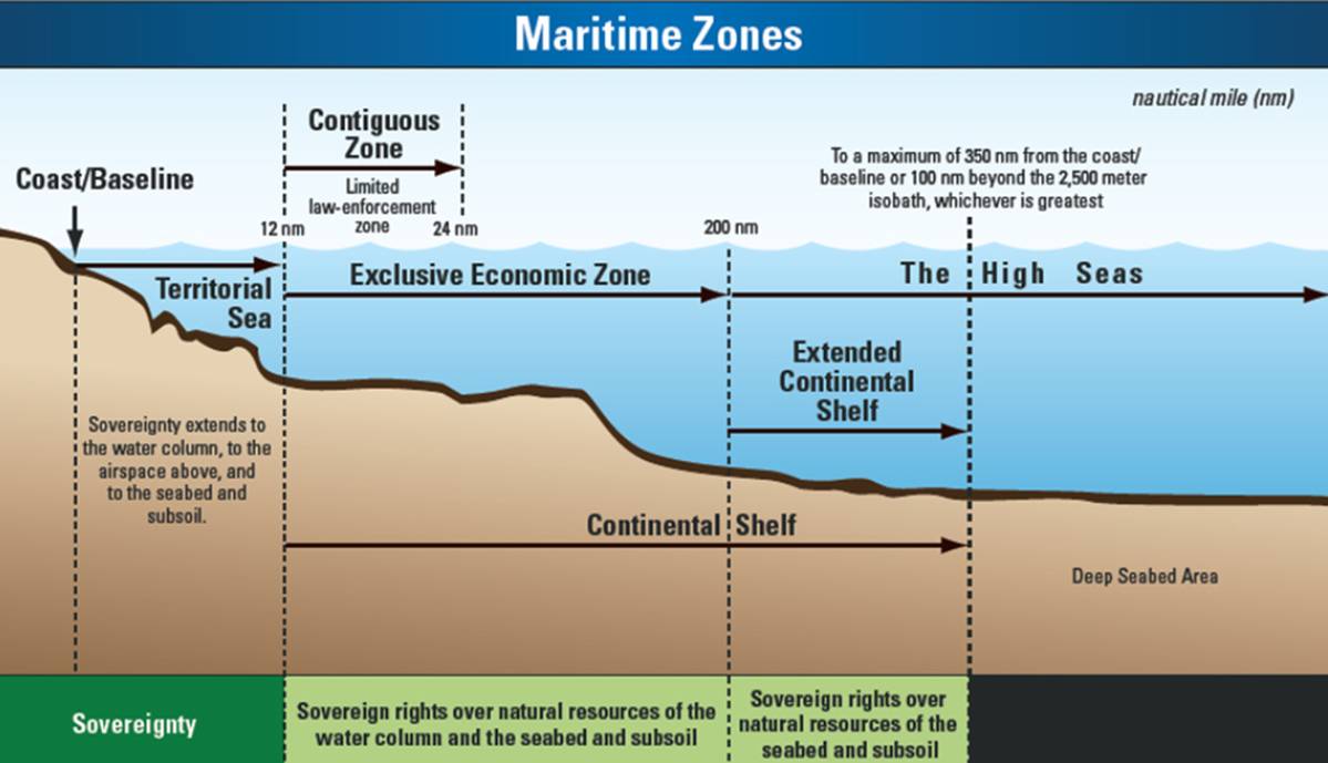
As most readers know, international law and convention allow coastal nations to extend control and influence far from a coastline. The “territorial sea” zone extends 12 nautical miles (nm). Then, the EEZ – or “exclusive economic zone” – extends further, to 200 nm. After that starts the high seas.
But that 200 mile EEZ endpoint does not denote the end of a nation’s extended continental shelf. That boundary can reach much farther. The rules and processes to establish ECS boundaries are complex, set within Article 76 of the 1982 UN Convention on the Law of the Sea. A nation establishes its boundaries based on bathymetric and seismic data. Importantly, there is another limit – the ECS cannot extend beyond 350 nm from a nation’s coastline.
Better Maps of Mars than the Ocean Floor
Setting the ECS boundary depends on two technologies:
-
Bathymetry: the use of multi-beam echo sounders, equipment which sends out sound pulses from a ship’s hull to the ocean floor. Depth and topography are determined by the period of time it takes for the sound pulse to return.
-
Seismic data: In a marine setting, seismic data starts with a vessel towing an airgun array, creating air bubbles and sound waves for subsurface, geological analyses.
The ECS project covered huge areas of ocean territory.
Since 2003, NOAA has mapped more than 3 million square kilometers of the ocean! Bathymetric data was collected on thirty-seven separate cruises, almost 2.5 years of sea time – the largest US offshore mapping effort ever.
The US Geological Service (USGS) headed up the seismic work which has totaled 28,105 linear kilometers! Data was acquired during ten field programs between 2007 and 2016. Six were cooperative missions with Canada. In the Arctic Ocean, the U.S. Coast Guard Cutter Healy collected bathymetric data and created a path for the Canadian Coast Guard Ship Louis S. St-Laurent, which followed and collected seismic data.
Airguns provide seismic data. Actually, mapping projects use an array of airguns which rapidly release compressed air, forming bubbles and sounds. Some sound energy is reflected back to the surface from the seabed. Some sound penetrates the seabed, reflecting off sediment or rock layers. Reflected sound is detected by hydrophones and acoustical characteristics are analyzed to provide seafloor information as well as sub-sea geological features.
Alex Demas is with USGS’ public affairs. He was asked how a vessel and crew, in an operative sense, set up and perform this at-sea research. He said it isn’t too much of a stretch to compare the sailing portion to the deliberate routings of a car with a camera on top working for Google maps.
Ships use GNSS (global navigational satellite system) for navigation and position accuracy combined with hydrographic survey planning software which allows the captain to plot and maintain a course and follow a straight line path. Real time data collection helps to ensure the survey accuracy. Ships may carry one or more types of echosounders.
Vessels sometimes start mapping as soon as leaving port, using the opportunity to collect data to help fill gaps in existing, but partial maps. However, Demas commented that using raw multibeam data presents significant storage and processing demands and can preclude a vessel from collecting data beyond its specific mission. The typical pattern for multibeam surveys is called "mowing the lawn:" the ship makes straight line passes back and forth across the area of interest. To maximize data quality, the line pattern is oriented to align with ocean conditions and the variation in bottom depth.
Demas said time at sea depends on a project’s location and goal. Mapping a shallow harbor may take a few hours. Distant projects can require weeks or months at sea. To maximize data collection, ships will run 24-hr operations 7 days a week, with the crew rotating on a 12-hr watch schedule.
USGS was asked about new technologies that have emerged, developments that could help speed up the work or otherwise advance this research.
Deborah Hutchinson, PhD, is a USGS ECS project leader. She said researchers collaborate when projects in remote locations provide the opportunity to collect sometimes unrelated data and to test new equipment. Some of the work she highlighted included –
-
testing a modified autonomous under-ice vehicle for data acquisition during a 2011 Arctic seismic cruise;
-
deploying an O-buoy to measure both water and meteorological parameters in an otherwise inaccessible Arctic area. (An O-buoy is an autonomous, GPS sea-ice tethered buoy that measures surface level ozone, carbon dioxide, bromine oxide and meteorological conditions, developed at Purdue University.);
-
making physical oceanography measurements whenever the ship stopped, to get water column properties in an otherwise inaccessible part of the ocean;
-
using a drone with infrared sensors to find thinner ice or to avoid Arctic marine mammals; and,
-
bringing ice observers aboard to calibrate satellite imagery with ice conditions for more accurate interpretation of satellite imagery.
NOAA was in charge of using these tech resources to draw ECS boundaries. The project data provides information pertaining to sediment thickness, changes in the gradient of the ocean floor and water column depth. These characteristics need to confirm geological links between a distant ocean point and a nation’s land mass. As noted, though, there is a 350-mile limit from a coastline, despite geologic commonalities. Importantly, the ECS is not an extension of the 200-mile exclusive economic zone which includes the seabed and subsoil and the water column. The ECS does not include the water column, just the seabed and subsoil. For example, see the map (below) of the US east coast that shows the EEZ boundary and the proposed ECS boundary; note the differences.
Why Draw a Line Deep Under the Sea?
To answer that question, program focus shifts: to the US Department of State (DOS), the lead agency for the ECS Task Force, the interagency body established to delineate ECS limits. DOS writes –
The United States, like other countries, has an inherent interest in knowing, and declaring to others, the extent of its ECS and thus where it is entitled to exercise sovereign rights. Defining our ECS outer limits in geographical terms provides the specificity and certainty necessary to allow the United States to conserve and manage the resources of the ECS
DOS was asked about a nation’s expanded sovereign rights and whether ECS boundaries present new responsibilities or opportunities. A spokesperson reiterated that the US has rights “to conserve and manage the living and non-living natural resources of its ECS.” Additionally, the US has jurisdiction over ECS maritime research “including rights relating to undersea pipelines and artificial islands, installations, and structures.”
However, the ECS is not considered the same as land territory. The terms used within international conventions and agreements differentiate among “jurisdiction,” for example, and “sovereign rights” and “sovereignty.” DOS explained that a country has “sovereign rights” within its ECS, and also “jurisdiction” over, say, marine research. However, these are considered “functional rights,” different from “sovereignty.” Nations cannot be denied passage or access within or through ocean areas above a nation’s ECS.
DOS was asked specifically about references to ECS zones and rights to conserve and manage non-living resources. Does that include sub-sea minerals and is a formal ECS boundary necessary to undertake or otherwise allow deep-sea mining and mineral recovery?
DOS replied that very little is known about most US ECS areas and that next steps need to include additional mapping and exploration to (1) better understand ecosystems, biodiversity, and resources and (2) assess the abundance and value of natural resources, which could include rare earth elements (significant in electronics, electric-hybrid vehicles and defense systems). ECS boundaries are not necessary to undertake mineral development, DOS said, but they “provide clarity regarding the areas within which a country may exercise authority.” DOS added that “the announcement of the US ECS limits does not signal any new plans for resource development.”
Next Steps
Procedurally, now that the ECS boundaries have been drawn on paper, so to speak, the US will submit related documentation to the Commission on the Limits of the Continental Shelf, an international body established by the UN to facilitate ECS implementation with the United Nations Convention on the Law of the Sea. The Commission considers a nation’s ECS filings. It makes recommendations regarding data and conclusions and can provide scientific and technical advice. A boundary is set once these recommendations are agreed upon as final.
With the US, the process gets confusing, however, because the US is not a party to the UN Law of the Sea Convention. The State Department writes, in its ECS Executive Summary, that the US “will file its submission package with the Commission upon accession to the Convention. The United States is also open to filing its submission package with the Commission as a non-Party to the Convention.” Or put another way, perhaps more clearly: The US will file with the Commission if it becomes a party to the Convention, or even if it does not because non-parties are allowed to file.
Next steps are not yet settled. The UN’s ECS Commission is in session this year, from January 8 through March. The recent US ECS work is not part of that Agenda. At the end of January, DOS had no further information regarding its timetable.