Enhancing Seafloor Mapping and 3D Modeling: The Role of ROVs in Photogrammetry Projects
By Deep Trekker
In the unexplored realms beneath the ocean's surface, a silent revolution is unfolding - a revolution driven by cutting-edge technology that transcends the boundaries of conventional seafloor mapping and 3D modeling, reshaping the landscape of data collection, observation, and modeling.
This article delves into the pivotal role of Deep Trekker ROVs, as the demand for accurate underwater intelligence amplifies across military, government, public safety, ocean science, maritime, and offshore energy sectors. Deep Trekker is standing at the forefront, unlocking a world of possibilities, and pioneering a new era of efficiency, accessibility, and reliability.
Empowering Efficient Data Collection
The adoption of imaging technologies to create 2D and 3D models is becoming much more common in seafloor mapping and the management of critical infrastructure. In many cases of submerged infrastructure, remotely operated vehicles (ROVs) are the only way to easily capture reliable data for modeling.
ROVs are a valuable tool for data collection, observation, and monitoring in underwater environments, significantly improving the accuracy and reliability of underwater modeling and seafloor mapping processes. They enhance the quality and quantity of data available for modeling, facilitating better understanding, analysis, and management of underwater environments and structures.
The Benefits of Using ROVs for 3D Modeling and Mapping
Accessibility and safety are key benefits of using ROVs for underwater modeling. They enable data collection in areas that may be difficult or unsafe for human divers, and can operate at significant depths, withstand high pressures, and navigate through complex underwater structures. Battery powered capabilities also make ROVs highly portable, allowing them to be deployed in remote areas or confined spaces that might not be possible to reach with dive teams. This is especially helpful in situations like offshore energy platforms, where inspection equipment is commonly flown in by helicopter.
Utilizing ROVs, operators are not required to obtain expensive or time-consuming certifications, and can immediately begin remotely surveying assets. This empowers nearly any member of a team to have the ability to inspect and scan structures in complex underwater environments, without any of the dangers associated with entering the water.
The use of different imaging sensors on ROVs, such as monocular cameras, stereo cameras, sonar, and laser scanners allow operators to capture data to build detailed digital twins in both 2D or 3D, even in turbid water conditions. Using cloud-based software, operators and engineers can share, view, and compare their underwater missions in granular detail. This data can then be logged, tracked, and monitored over time. The resulting portfolio of information provides asset management teams with invaluable insights to help optimize asset management practices.
Positioning is often another challenge underwater. GPS and GNSS sensors are often useful for tracking assets above water, but these sensors do not work underwater. Working in conjunction with the collected visual data via camera or imaging sensors, ROVs equipped with Ultra Short Baseline (USBL) and Doppler Velocity Log (DVL) sensors can accurately pinpoint and display their location on a map to provide an experience close to that of GPS. This adds an additional layer of data to surveying, allowing operators to not only generate detailed models but also understand and track the relative position and size of the location or asset being modeled.
These advanced positioning and stabilization systems have also been developed into methods of performing autonomous surveys without user input, such as Deep Trekker's Mission Planner feature. This streamlines any repeated survey of a fixed structure since the route is pre-programmed and repeatable, with active yaw stabilization to combat unpredictable current patterns. Additionally, beginner pilots can use these functions to lessen any learning curve, as human interaction is reduced.
Necessary Equipment for Photogrammetry
To embark on a successful photogrammetry project, you'll need specific equipment tailored to the task. Here's a breakdown of the essential tools required for underwater photogrammetry.
-
Deep Trekker ROV - equipped with an enhanced 4K camera serves as the foundation, enabling underwater exploration and data collection.
Optional Add-ons
-
Mission Planner - Enables precise survey mission planning and execution with autonomous navigation.
-
USBL - Aids in tracking the ROV's position with high accuracy
-
DVL - Provides stabilization, speed, and directional information, enhancing the photogrammetry process.
-
Sonar - Allows for underwater mapping of terrain or assets in low visibility water.
-
Laser Scanners - Can be used to achieve accurate measurements of assets or objects of interest.
Case Study: Stantec Using Deep Trekker ROVs for 3D Archaeological Modeling
Mission Objective
Stantec Markham's archaeological department was tasked with evaluating a dam structure in Nassau Mills in Peterborough, Ontario. This site housed an active dam that was approaching the end of its functional lifespan, as well as the historical remains of a previous dam from the 1800s. The goal of this survey was to examine the historical remains, while also identifying the construction methods used in past dams for new building plans.
The Equipment Used
Deep Trekker's REVOLUTION and PIVOT ROVs were used in conjunction to provide extended battery life to last through the whole workday. Both of these devices are equipped with six thrusters, as well as rotating camera heads and tool platforms. Four of the six thrusters are vectored, while the remaining two are vertical, allowing for lateral and vertical movements without adjusting the ROV pitch.
Phase 1: Imaging
The first phase of Stantec's photogrammetric modeling was the gathering of high-resolution images. The first challenge this project faced was the weather. The survey needed to be conducted during Canadian winter, with average low temperatures of -11 degrees Celsius for the area. Sending divers in at these temperatures would require extensive gear, and result in shorter dive times to limit exposure risk. Secondly, working near a dam structure produces high current and risks of differential pressure.
Project Archaeologist Mike
Maloney stated, "If we had divers down, we're very close to a dam,
there'd be a lot of safety concerns getting the work done." To
address these issues, Mike, alongside Darren Kipping, another
archaeologist at Stantec, decided a Deep Trekker ROV was the
best tactic for imaging. By equipping the ROV with a 4K camera set
to take images every five seconds, the duo was able to pilot
the ROV in a grid pattern for extensive photo coverage from
varying angles. This tactic was able to capture near continuous
images by field swapping between two vehicles.
The pair explained that they were able to conduct the underwater survey much quicker than usual. Noting that, "Normally if we had divers down, we, as the archaeologists, would instruct them what to be looking for, what to record, and then they would come back up and inform us of what they've seen." In a single afternoon, the team was able to capture all the imagery needed to move onto the second stage: modeling.
Phase 2: Modeling
Once the necessary imagery was captured, Mike and Darren were able to upload their findings, alongside some previous side-scan sonar footage to generate photogrammetric models using photogrammetry software. Modeling software performs photogrammetric processing of digital images and generates 3D spatial data to be used in GIS applications, cultural heritage documentation, and visual effects production, as well as for indirect measurements of objects of various scales.
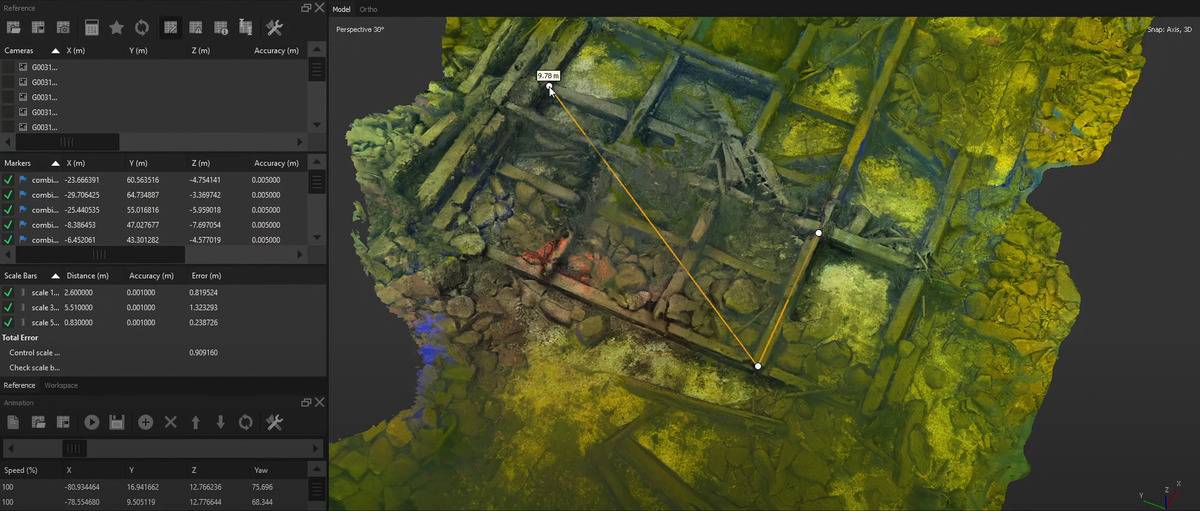
The figure above demonstrates the capabilities of precise measurements found in the modeling process. The images captured were able to render completely interactive models down to millimetric accuracy. Once finalized, Stantec was able to compare the photogrammetric renderings against historical documents to track the impact of environmental factors over time.
Key Takeaways
Using Deep Trekker ROVs, Stantec was able to quickly, safely, and easily capture all the photos needed for modeling in a single day. The speed at which two team members were able to complete a task like this was remarkable. By deploying ROVs, the pair of archaeologists could direct the vehicles to exactly where they needed to be, rather than communicate back and forth with a dive team. By empowering the end-user to capture the required images, they successfully created high-detail 3D photogrammetric models of Nassau Mills dam, with no risk or repeating costs.
Elevate Your Underwater Operations with Deep Trekker ROVs
In the dynamic world of seafloor mapping and 3D modeling, Deep Trekker ROVs emerge as indispensable tools, transforming how professionals navigate and explore underwater environments. From military and government applications to public safety, ocean science, and offshore industries, this technology provides unparalleled precision and efficiency, empowering professionals to navigate the depths with confidence and precision. Elevate your operations with Deep Trekker ROVs - a steadfast ally in the quest for comprehensive underwater intelligence.