Interview
Ian Davies, International Hydrographic Portfolio Manager, UKHO
The Evolution – not Revolution – of Seabed Mapping
When it comes to seabed mapping, fewer names are more prestigious or better known than the United Kingdom Hydrographic Office (UKHO). Ian Davies, International Hydrographic Portfolio Manager, UKHO, has enjoyed a diverse and 30+-year career in hydrographic survey. In this interview with Marine Technology TV, he shares his insights on the market drivers and the technology – from autonomy to communications to data processing – that he believes will deliver one of the most exciting and fast-moving eras in hydrography.
By Greg Trauthwein
Ian Davies, International Hydrographic Portfolio Manager, UKHO, is not unlike many colleagues in the sector: a life devoted to the subsea industry with many interesting stops along the way. For Davies, his long career in hydrography had a bit of an unusual start, when in 1989 he opted to specialize as a hydrographer in the Royal Navy.
“I completed my probationary time on HMS Herald and I started off doing oceanography and then ended up doing surveys and mine warfare supports in the Gulf before completing my category B in hydrography,” said Davies.
Following a number of appointments on Royal Naval vessels, he completed his category A in hydrographic surveying in mid 1990s.
“I was privileged to take command of HMS Gleaner, at the time the Navy's smallest commission warship, and I spent a couple of very profitable years surveying around the United Kingdom, building my experience, really getting to know what hydrography was all about,” said Davies.
Following that, he went into a staff role and became responsible for programming the Royal Navy's survey vessel, followed by a two-year gig to teach the Royal Navy's course in Hydrographic surveying and then a spot at UKHO to manage surveys around the UK for the UK Civil Hydrography program.
“About 2006, I decided that my time had come to an end, having done a long time in the Navy, I went into the commercial sector working for a small specialist survey company, and that opened my eyes up to the different areas of seabed mapping,” said Davies.
After a few related commercial stints, Davies rejoined UKHO in 2017 and never looked back.
UKHO Today
With about 1,000 staff located in the southwest of the U.K. in Taunton, the UKHO is the arguably the largest hydrographic office in the world.
“We receive data from hundreds of partners and sources across the world,” said Davies, “and the product portfolio that we produce includes a series of over 19,000 electronic navigational chart, available to the mariner through our distribution network of 182 offices. At the latest count, around 90% of the world's major shipping has our products on board.”
As one of the largest and most influential hydrographic offices, the UKHO’s obligations stretch far beyond its shores, with 63 other nations provided ‘significant support.’
“These are in our primary charting portfolio, so we help them meet their international obligations and we also support over 30 digital partners in making sure that this information is made available to the mariner as required by the Safety of Life at Sea convention,” said Davies. “But now it's also providing a wider awareness to countries of their marine estate, and that's now being used to help around things like sustainable management and development of the marine or blue economy.”
Hydrographic Technology Evolution
With his long career in hydrography, Davies has had a front and
center seat to watch the development of new and revolutionary
technologies to make the process faster, better and more efficient.
At the start of his career, it was traditional … single beam echo
sounders, horizontal sextant angles … all of the tools anyone with a
long career in hydrography would recognize.
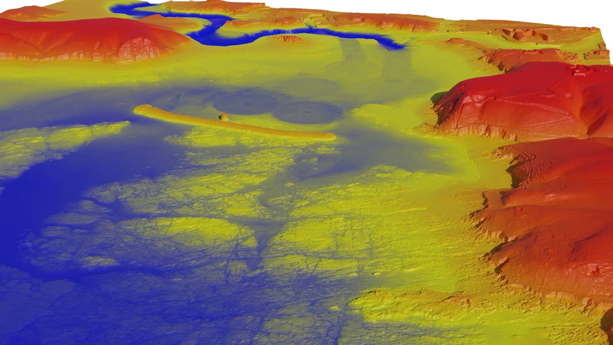
“I think the first change that was significant was the advent of GPS,” said Davies. “We began to use GPS as a source of positioning and that has continued to evolve to this day into GNSS, with accuracies down to millimeters depending on the kind of ways that we handle and process our data. The other one was the introduction of digital systems that were recording depths, position and time electronically. That made a huge difference. It made the workflows easier. As we move forward, the late 1990s saw multibeams to become more common, we began to talk about the future and how we could integrate these sensors into seabed mapping.”
As is seen throughout industries globally, the challenge now is the sheer volume of data. “Each generation of sensors is gathering more data,” said Davies. “When we look at the IHO and we think about the standards – nine pings per two-meter bin for a nautical charting survey, we struggled to do that at the beginning. Now we struggle to get less than 30 or 40 soundings in that two-meter bin, and that creates a new set of problems for us in this digital era because data volumes have grown in size.”
Gone are the floppy disk and in are the tens of terabytes of data that must be retrieved, processed and analyzed.
Another technology that has significantly impacted the hydrographer’s ability to work effectively, efficiently is satellite derived bathymetry. “It's obviously limited to the shallower, clearer waters, but it allowed us to look at large areas very quickly,” said Davies. “The evolution of airborne lidar bathymetry was also fundamental from 2007-08, onwards, and we've seen an explosion in the capability of those systems and in the current generation, the sensors now are working down to about 15 meters, maybe a little bit deeper.”
While the change has been dramatic, Davies still sees the tools of the hydrographic trade as “an evolution rather than revolution,” stressing that the “old techniques remain valid” because at times you need to fall back on the old ways of checking something, maybe calibrating your multibeam using a lead line, for example.
Looking ahead, particularly as artificial intelligence and machine
learning continue evolving, Davies envisions a strong role of both for
the hydrographer, particular in the handling and process of
information.
“I've already mentioned the issues about data
volumes; they're increasing and more often than not, now we're
gathering more than one data type,” said Davies, noting that when a
vessel is out working, they aim to collect as much information as
possible.
“I think the introduction of AI and machine learning is going to have a huge impact,” said Davies. “What it's going to help us do is better manage these huge, ever-increasing volumes of data, and I think a lot of people are getting worried about that, thinking ‘well, there goes the role of the hydrographer.’ To me, I think the role of the hydrographer will evolve, meaning we're going to be able to focus our skills on more specific areas and use the machine learning tools and AI tools to perhaps remove some of the drudge.”
Take 20 minutes and watch the full interview with Ian Davies, International Hydrographic Portfolio Manager, UKHO, on Marine Technology TV. In addition to the areas covered above, Davies takes a deep dive on:
-
Autonomy and its impact on hydrographic surveys in the future
-
The UKHO’s roles in Seabed 2030, the quest to map the worlds oceans completely by 2030
-
The role of seabed mapping to the whole ocean health conversation