Feature
Ocean Observation
S-MODE
Gathering Ocean Intel from Above, On and Under the Waves
The Sub-Mesoscale Ocean Dynamics and Vertical Transport Experiment (S-MODE) is deploying multiple high-tech assets – in the air, on the water and under the water – to discover clues on small-scale ocean dynamics that can help scientists better understand how oceans impact the Earth’s climate system.
By Greg Trauthwein
Wave Gliders on the deck of R/V Oceanus prior to deployment during S-MODE 2021
Photo courtesy Scripps Institution of Oceanography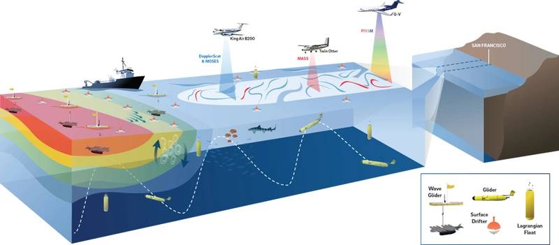
Scientists and researchers across a range of organizations are engaged in a NASA-led campaign 110 nautical miles off of San Francisco to study small-scale ocean processes and dynamics, a study that is aiming to deliver better understanding of how these small processes impact the atmosphere above and below the waves. Perhaps more importantly, the S-MODE project aims to gather and correlate information from below, on and above the waves, a study that could eventually lead to tracking these small-scale processes via satellite to help better predict the weather and future climate.
"What I try to do is to develop better understanding of the coupling between the ocean and the atmosphere,” said Luc Lenain, Director of the Air-Sea Interaction Laboratory at the Scripps Institution of Oceanography. Lenain, a physicist with a strong focus on observational sciences, recently interviewed with Marine Technology TV on the project, and a participant in the S-MODE project. “In particular, I'm interested in the role of all of those upper ocean processes that will lead to turbulence, to all kinds of small scale to larger scale physical processes that will have an impact on larger scale understanding of the ocean.”
The Problem
A major difficulty in simulating Earth’s climate system is that there are interactions across scales, so that the large time and space scales can be sensitive to processes on small scales. As the computational resolution of global ocean models has improved, scientists have begun to suspect that kilometer-scale eddies and fronts, called submesoscale variability, have a net effect on ocean-atmosphere heat exchange that is larger than the heating from the greenhouse effect. According to Lenain, small processes like eddies and fronts aren’t understood all that well, and S-MODE was designed to better understand and to better model these sub-meso scale processes, to then better understand and better predict the Earth's climate system. “To develop a better understanding of the physical processes at the sub-meso scales and how it fits with the larger scale processes, you need to collect observations; and collecting observations at those scales are extremely difficult.”
State-of-the-art computer models agree in predicting that these eddies have important long-term effects on the upper-ocean, but their predictions are sensitive to relatively small details in model physics and implementation. The resolution and detail of these simulations has surpassed the ability to ground truth them with spaceborne or in situ sensors. So there is a need for a comprehensive benchmark data set on these submesoscale motions to address this source of uncertainty in simulating the global ocean.
The Project
S-MODE aims to test the hypothesis that submesoscale ocean dynamics make important contributions to vertical exchange of climate and biological variables in the upper ocean. The S-MODE project will deploy in a series of three studies, the first of which was completed in October 2021, with two more experiments scheduled; one in October 2022, and another one in April 2023. During the project researchers will deploy a coordinated saturation of assets in the air, on the water and under the water to collect data, leveraging advances in computing power and data density and resolution to better understand the ocean’s very small processes, to see how they interact with the larger sea and air processes, ultimately giving scientist a better understanding of the small process to better predict what will happen in and around the ocean.
“We will use research aircraft so that we can do airborne remote sensing of the ocean surface,” said Lenain. “Three aircraft to tell us about surface current, to tells us about waves, and to tell us about ocean color and ocean temperature.”
“The aircraft instruments provide spatial observations but can’t penetrate the ocean’s surface, while the autonomous vehicles and ship are providing in situ observations of the upper-ocean ,” said Lenain. Used in conjunction, these data show what is happening over an area of the ocean surface and into the depths below.
While the project has been discussed and planned for nearly three years, the execution was delayed due to the COVID pandemic. Starting in the autumn of 2021, for three weeks two aircraft flew repeatedly overhead to collect measurements from above while the vessel and the autonomous vehicles sampled the ocean below. From 28,000 ft. in the air, the NASA Armstrong King Air B200 used it DopplerScatt instrument to bounce radar signals off the ocean to provide information about winds and currents at the surface. While the MASS instrument aboard the Twin Otter DHC6 plane flew below the clouds to observe the properties of the ocean surface at higher resolution.
The “eyes-in-the-sky” perspective from the aircraft enabled the team to monitor a large swath of ocean at once, as well as direct the research ship and autonomous ocean vehicles in the water to move toward areas of interest.
Planes, Ships & Subsea Systems
Partners include in the S-MODE project include Woods Hole Oceanographic Institution, Scripps Institution of Oceanography, University of Washington, NASA, (NASA JPL is a central part of the project, flying to suborbital instrument, DopplerScatt, and PRISM).
To ensure that all of the individual entities, assets and technologies tied together in a cohesive manner, Lenain said that the team took cues from NASA in creating a control center. “It gets complicated, especially during COVID, to organize and coordinate all those assets,” said Lenain. Central to the project was putting together a core leadership team with an emphasis on the communication between all groups, “a mission center that had the ability to gather real-time data from all assets, giving the ability to make new, real-time decision on what to do next.”
While the aircraft collect data on wind, currents and ocean properties from the sky, the ship R/V Oceanus took similar measurements from the ocean surface. The ship also served as a launching point for a small fleet of several types of autonomous ocean vehicles, including Wave Gliders, joined by several Saildrones that sailed from San Francisco Bay to join the fleet collecting data at the study site. The Saildrones and Wave Gliders measured a vast array of factors such as ocean currents, wind speed and direction, air and water temperature, salinity, dissolved oxygen, and chlorophyll content.
In addition, two kinds of trackers floated freely in the water, providing information about where and how currents are moving and interacting. The drifters remain on the surface, while the Lagrangian Floats follow the underwater ocean currents in three dimensions.
With all these instruments working in coordination with each other, with the vessel, and with the aircraft, the team hopes to capture rapidly shifting ocean currents and properties within the study area, sampling a small patch of ocean to derive a comprehensive multi-faceted view.
“My group operates the Modular Aerial Sensing System (MASS) instrument, an instrumentation package that is designed to gather detailed high-resolution observation of surface waves and ocean topography – kind of like swaths of surface wave – along with ocean color, hyperspectral imageries,” said Lenain. “We have LIDARs (which pack powerful sensing capability in a small package) to get information about ocean surface conditions. DopplerScatt is a Jet Propulsion Laboratory (JPL) instrument designed to produce map of ocean surface current and surface winds over very wide swaths (in the order of tens of kilometers) “which is really important when you want to study those eddies, and other sub-meso scale features. You will be able to capture their specs, their lateral extent, and how they evolve in space and time.”
Another tech, PRISM, is a hyperspectral system that measure ocean color.
“Once you have observations of the ocean surface, can you actually tell something about what's happening underneath,” said Lenain. “How do you relate those surface observation to the underlying ocean dynamics? That's an important goal for S-MODE, especially in the context of future NASA missions, as you can envision that some of those instrument would transition to an orbital satellite system,” giving scientists a powerful new tool for expanded, global observational coverage, using those service observations to better predict what’s going on under the surface and to provide better forecasting.
MASS data collection inside the Twin Otter during the 2021 S-MODE field experiment.
“To better understand what the aerial assets are ‘seeing’ the project had in-situ assets, underwater gliders that measured information about salinity, density, temperature over a broad range of depths,” said Lenain. “We had various drifters that tell us information about currents and convergence zones and those whirls and small eddies.”
Finally research vessels are doing more traditional sampling: biology, temperature, and salinity profiles, etc. “The key here is, by having those collocated coincident observation of the ocean surface and those observation with in-situ assets, we're trying to develop better understanding of the physics of the very upper ocean so that, hopefully at some point, we'll be able to say something at about the deeper ocean, or the upper ocean dynamic just from the surface observation that you could get ultimately from a satellite.”
While the project is still in its infancy, Lenain did note an early interesting finding. “Just looking at the data that I've collected, one thing that is really striking is how much temporal variability you see with those kind of processes. You know, those things are those small-scale, sub-meso scale features, eddies that are moving very rapidly, which is really exciting, and very interesting. I think this is going to help us better shape the next round of experiment.”
S-MODE is part of NASA’s Earth Venture Suborbital-3 (EVS-3) program, funded by the Earth System Science Pathfinder (ESSP) Program Office at NASA’s Langley Research Center in Hampton, Virginia, and managed by the Earth Science Project Office (ESPO) at NASA’s Ames Research Center in California’s Silicon Valley.
Teledyne Marine ADCPs
The S-MODE project effectively deployed a wide variety of advanced sensors and systems, including Teledyne RDI ADCPs, deployed on the Liquid Robotics Wave Glider, the Saildrone vehicle and the Research Vessel Oceanus, according to Paul Devine, Teledyne Marine.
“Starting with the Wave Glider, there's 300 kilohertz ADCP that's capable of measuring the upper 100 meters of the water column, allowing researchers to begin to understand the coupling between the surface conditions and those below the surface,” said Devine.
“Teledyne ADCPs have been an important instrument in the project because they provide ocean currents from a few meters depths up to 100 meters; that gives us a big picture,” said Lenain. “Those sub-meso scales are on the order of one to several tens of kilometers. And one of their characteristic is that they evolve very rapidly in space and time. So putting a mooring and, and attempting to study those processes is not sufficient because you only have one-point measurements. So one of the things that we've done as part of the project is use those ADCP sensors, those current profilers, and install them on those autonomous surface vehicles that move around.”
“As a scientist, it is one thing to collect observations; It is another thing to collect observations that are meaningful, that has the right accuracy to study the process that you're interested in,” said Lenain. “That's some things that we've done as part of the project and concluded that those ADCPs had sufficient accuracy to resolve the physical processes we were trying to study.”
S-MODE Goals
The Sub-Mesoscale Ocean Dynamics and Vertical Transport Experiment (S-MODE) will test the hypothesis that submesoscale (1-10 km) ocean dynamics make important contributions to vertical exchange in the upper ocean. The science goals include:
- 1. Quantitatively measure the 3D structure of the submesoscale features responsible for vertical exchange.
- 2. Quantify the role of air-sea interaction and surface forcing in the dynamics and vertical velocity of sub-mesoscale variability.
- 3. Understand the relation between the velocity (and other surface properties) measured by remote sensing at the surface and that within and just below the surface boundary layer, and;
- 4. Diagnose dynamics of vertical transport processes at submesoscales to mesoscales.
Watch the Waveglider in Action!
Video courtesy Scripps Institution of Oceanography