Dredging
New Orleans is Sinking, and it is Not Tragically Hip
Mother nature and climate change are having major impacts on navigation on the Mississippi River Ship Channel.
By Sean Duffy, Executive Director, Big River Coalition
Active and dramatic changes are having major impacts on the Mississippi River Ship Channel—the waterway I worked on most of my life, from Baton Rouge to the Gulf of Mexico. I have been reminded of a song from a Canadian band I worked with between maritime positions decades ago. The song is the Tragically Hip’s “New Orleans Is Sinking”, and one line has prophetically been stuck in my head the last few years:
My memory is muddy, what’s this river that I’m in?
New Orleans is sinking, man, and I don’t wanna swim…”
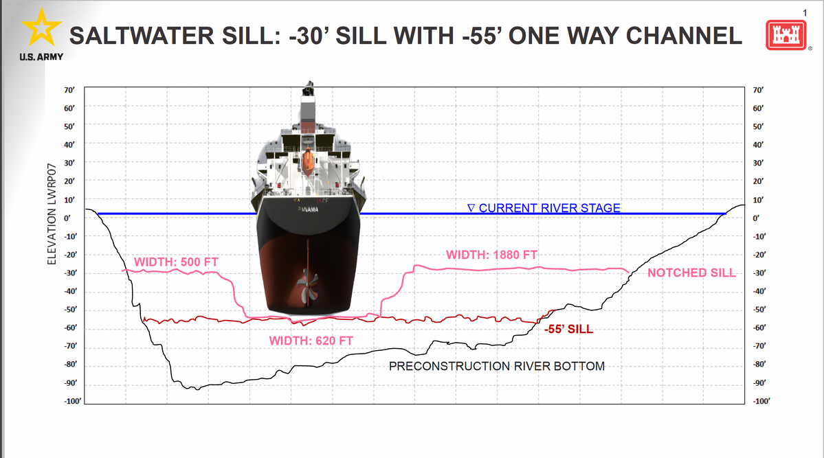
It is a wonderful song, but I had no idea at the time how much truth it contained and how much my career would change. Not only is New Orleans sinking, but it’s drowning under the invasion by the Gulf of Mexico through active sea-level rise. The last two years saltwater has been flowing upriver against the reduced flow of the Mighty Mississippi. The flow in the riverine system has always been dependent upon precipitation. Droughts have caused low river stages and saltwater encroachment throughout our history, but the average had been extreme drought once a decade. The Bonnet Carré Spillway had to be opened in back-to-back years for the first time ever and then twice in the same year, operated in 2018 and then 2019 and then a second time in 2019. The forecasts then predicted we would see more high river stages. Yes, the spillway was also operated in 2020, but river stages since 2020 have not approached high river levels. In 2022 the saltwater encroachment led to the required mitigation through the construction of the saltwater sill. The last time this was required was in 2012, right on the average.
The flood of 2019 passed the largest volume of water down the Mississippi River with flows over 1 million cubic feet per second. But in 2022 and then 2023 the total flow was reduced to 120,000 cubic feet per second. The saltwater sill is in essence a levee built on the bottom of the river with dredged material pumped into place by a cutterhead dredge. The method used in 2022 was different than that of 2012 and worked surprisingly well, a credit to Weeks Marine and the U.S. Army Corps of Engineers. Then in 2023 the method was improved, and the maritime industry was more prepared because it had just experienced extreme low water conditions and operations on the Mississippi River Ship Channel requires focus on ever changing conditions.
During this time, I began getting questions from longtime river pilots, discussing things they had never seen and most likely no one had ever seen. I was tasked with seeking explanations and luckily had a close relationship with several scientist of Tulane University’s River-Coastal Science & Engineering Department. I had used some river flow metrics provided by one of their colleagues to start trying to better understand why we needed to dredge in Southwest Pass with a reading of 3.5 feet on the Carrollton Gage (New Orleans) a long-held standard was that we needed dredges in Southwest Pass when the Carrollton Gage was at 10 feet or higher. The diagram I developed detailed the loss of flow from Belle Chasse at 776,000 cubic feet per second with a reading on the Carrollton Gage of 12.1 feet, through multiple crevasses. Then it struck me that vast majority of these crevasses or breaks in the river bank are on the eastern side of the Mississippi River, or in nav speak, the left descending bank. With help from the folks at Tulane and blanks filled in by the U.S. Army Corps of Engineers to account for measurements at all the crevasses on the same day, it showed the loss of flow at the Head of Passes - the entrance (or exit) to Southwest Pass was reduced to just 226,000 cubic feet per second. The mystery that had started this journey was the need to dredge just a mile below the Head of Passes, or in Mississippi River lingo, Mile 1.0 below Head of Passes. Then it struck me, not only was the loss of flow due to the formation or growth of crevasses, but the original Pass deepened by Captain James Buchannan Eads. South Pass or Port Eads had just been dredged for the first time in 14 years, and due to the increased flow that channel now pulled more water. On May 24, 2022, that was the equivalent of 61,378 cubic feet per second of water. I have since compared the Mississippi River to a garden hose with a number of holes in it; most of them, including all the large ones, are on the eastern side. The eastern side is ground zero, the low unprotected side. Neptune Pass is the largest of the crevasses but is truly a maze of crevasses that grew during the great flood of 2019, with over 118,000 cubic feet per second leaking out of the nation’s garden hose. This caused shoaling in the channel and for the first time ever required dredging at Mile 22 above Head of Passes. Until five years ago we had never dredged above Mile 11 above Head of Passes.
As part of my research, I reached out to one of the Tulane scientists. I had an educated theory but am a navigation guy and find academia to be intimidating—even for a former rugby player like me. I had a pretty good idea that my explanations would make sense but was a little surprised to hear, “Sean, not only are you right, but our research and modeling will verify it.” Then came the scary question: how would the navigation industry deal with climate change? “New Orleans is sinking, man, and I don’t wanna swim…”
Relative sea-level rise impacts have been felt along the East and West Coasts, but nowhere can it be more damaging than on the third coast: the Gulf Coast. The garden hose analogy still applies. If you put a lot of water through a leaky hose, the holes get bigger, and loss of stream power on Big Muddy means shoaling happens more often in the nation’s most prolific and sediment-rich waterway, which leads to shoaling impacts in the channel. The Bohemia Salinity Control Structure failed in the flood in 2011, the weak point here was self-inflicted as a cut in the river was constructed, ironically, in an attempt to divert water from the Big River in an area of rich oyster grounds to help reduce or control salinity. The structure did not operate for decades, and after some tinkering in the response to the Deepwater Horizon oil disaster in 2010, the area collapsed in the next high river stages in the flood of 2011. Neptune Pass grew from capturing 6% of the thalweg from the Ship Channel to over 30% during the flood of 2019. These crevasses function like straws, and the water can and does flow in both directions. During high or medium flow in the river they flow outward, causing the crevasses to grow. During low water the water flows inward.
I was asked to co-author a scientific journal with some of the Phd river scientists that detailed a lot of this information and raised the level of concern. Resilient ports could possibly be developed, but as deltas drown in relative sea-level rise, can we adapt our waterways to be resilient?
The following quote is reproduced from the abstract of this study with the catchy name: “Impact of Water Loss on Sustainability of the Mississippi River Channel in its Deltaic Reach” by Dr. Mead Allison, Dr. Ehab Mesehle, Dr. Barbara Kleiss and Sean M. Duffy, Sr. (MS River Navigation Guy).
Together these results indicate that (1) river containment and the sustainability of the navigation channel is threatened, (2) sediment load reaching the seaward end of the delta may be insufficient to avoid major degradation, and (3) the increased freshwater flux into adjacent shallow coastal water bodies has unknown implications for coastal hypoxia and food webs, including commercial species (e.g., oysters) and marine mammals. Future acceleration in sea level rise rates and tropical storm frequency/intensity likely will worsen these trends.
This may not be my only published scientific study as the band is getting back together with a few more contributors to delve deeper into some of the impacts caused by changes to the sediment load. But climate change is here. The National Oceanic and Atmospheric Administration’s National Weather Service’s Lower Mississippi River Forecast Center has confirmed that due to the influence of the Gulf of Mexico the Carrollton Gage no longer accurately reflects river stage measurement during low water periods, and that discharge flow at Red River Landing is also compromised due to the Gulf advancing upriver. The lowest reading on the Carrollton Gage in modern history happened during the extended drought of 1988, with a reading of 0.1 feet. The lowest reading during 2023’s extended low water was 1.1 feet (November 29, 2023 at 1400 hours); I remember because I almost fell out my chair when I saw the gage. I called both the Corps and National Weather Service who confirmed the gage was operating properly and that this was the lowest reading in a decade. The Carrollton Gage during low water periods is also now influenced by tidal variance and wind direction, changes that have again never been seen before.
The fact that New Orleans is sinking is more Tragic than Hip. This Mighty River is being challenged now. These changes are occurring rapidly and will require holistic coordination to fill in the crevasses and preserve the stream power. Captain Eads knew almost 150 years ago that the way to reduce, prevent or wash away sediment was to keep the flow in the river. He harnessed the river’s power to scour out South Pass, the main channel was moved to Southwest Pass, but hydraulics do not change with a software update. The laws of water remain unchanged.
Captain Eads was influenced by another famous leader, Robert E. Lee, when he was a captain at the U.S. Army Corps of Engineers in 1837. To remove sandbars that were solidified by tree growth and blocking the flow of the river and hampering navigation, Lee responded by building a jetty that focused the water pressure on these islands. The islands or snags were washed away by the stream power. When you are working in your yard and want to wash dirt off the sidewalk, you put the hose’s nozzle on the jet setting, not shower. Keeping the flow in the river is critical to our future, and a concerted effort to do so will buy time to help better address our response to sea-level rise to protect New Orleans and the nation’s economic superhighway.
Today, not only is the nation’s most prolific channel under threat, but there are also two major studies ongoing that question whether the Big River is sustainable.
Sometimes well-known quotes can be multigenerational, like this one from “The Rime of the Ancient Mariner”, by Samuel Taylor Coleridge: “Water, water everywhere, nor any drop to drink.”
Saltwater encroachment is an active threat that will challenge our ability to provide freshwater for the city of New Orleans. Areas below New Orleans had salinity levels that exceeded the 250 parts per million threshold the Environmental Protection Agency enforces tenfold for approximately 9 months. America’s great river, our farmland, drinking water and the ship channel that has an economic value of approximately 7% of the annual gross domestic product (GDP) for the country are at risk.
Climate change is here, already happening on waterways and aquifers across the country. Port and navigation industry representatives must get engaged, follow and comment on the U.S. Army Corps of Engineers study known as Lowermost Mississippi River Comprehensive Study. The National Academy of Sciences funded study Mississippi River Delta Transition Initiative Consortium or Miss Delta should be on the radars of our industry and our Congressional leadership.
Who knows what the next high or low water will reveal? There are actions that can help, but we have never been so close to drowning or sinking. Climate change is rolling on the river…
About the Author
Sean Duffy is executive director of Big River Coalition, an organization committed to ensuring the future of navigation on the Mississippi River Ship Channel (MRSC).
